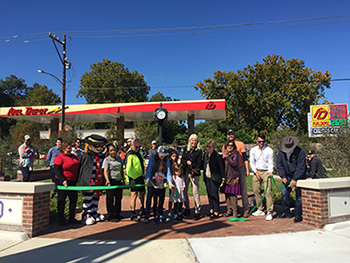
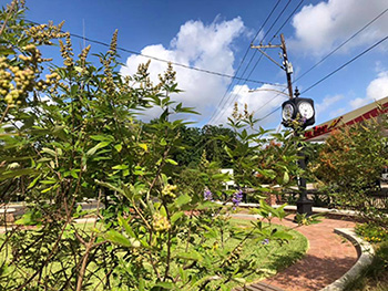
Houston Avenue & White Oak Drive Esplanade (Completed 2019; Ongoing Maintenance by GNMD Starting Summer 2020)
Constructed by Community Partner: Memorial Heights Redevelopment Authority/TIRZ No. 5
In 2019, Memorial Heights Redevelopment Authority/TIRZ No. 5 completed the intersection improvements of Houston Avenue and White Oak Drive to include the realignment of the intersection to improve safer crossing conditions and connectivity to park and bike routes. The project included the beautification of the gateway space at the northeastern corner of the intersection with new roadway pavement, traffic signals, shared use path, bicycle amenities, pedestrian facilities and landscaping. The old clock was refurbished to decorate the new greenspace. As a maintenance partner, GNMD will maintain the Esplanade project landscaping.
GNMD Stakeholders for Capital Project
Plans by other entities:
- City of Houston Resiliency Plan – Resilient Houston provides a framework for collective action for every Houstonian; our diverse neighborhoods and watersheds; City departments; and local, regional and community partners.
- Complete Communities – The Near Northside Complete Communities Action Plan outlines the vision, policies, goals and projects identified by stakeholders and that work toward a vision of a healthier, more resilient, prosperous and equitable future for the community.
- Elysian Viaduct – This project includes the Elysian Viaduct bridge reconstruction from Brooks to Commerce Street to improve safety, accommodate population growth, enhance mobility and improve connectivity in the local area. The Texas Department of Transportation (TxDOT) is finalizing the reconstruction of the Elysian Viaduct bridge from Brooks to Commerce Street. GNMD partnered with former Senator Sylvia Garcia’s office to support the painting of the columns under the new bridge. Artist Nicola Parente finalized the color scheme.
- Halls Bayou – With new trails, pedestrian bridges, wayfinding, educational signage, benches and landscaping, Halls Bayou Greenway creates spaces for exploration and play, including a playground for children with disabilities; playing fields; trails; and a large, scenic detention basin with wetlands designed for flood control.
- Hardy Toll Road Downtown Connector – This project extends the Hardy Toll Road from its current southern end at the I-610 North Loop into downtown Houston. When complete, the project will give commuters a direct 25-mile link between downtown and destinations to the north and will allow drivers to bypass congestion at I-610 North, I-45 and I-69.
- Heights Northside Mobility Study – The area defined by this study is bounded on the east by I-69, on the south by I-10 and on the north and west by I-610. The study will identify near- and long-range projects that promote better mobility.
- High Speed Rail – This project involves the development, design, construction, finance and operation of a high-speed passenger train line that will connect North Texas and Greater Houston in less than 90 minutes.
- Houston BCycle – Houston BCycle is operated by Houston Bike Share, a local 501(c)(3) nonprofit. The organization provides access to bike share that fosters recreation, mobility and personal wellness. Multiple locations have been installed in the Northside and expansion plans exist.
- Houston Bike Plan – The Houston Bike Plan was adopted in 2017 to implement projects in the Near Northside. Projects have been included on Lyons Avenue, Hardy Street, Elysian Street, Kelley Street and McKee Street. Future short-term projects include Burnett Street, Quitman Street, Cavalcade Street and North Main Street.
- Houston General Plan – Plan Houston describes a vision for Houston’s future and identifies the policies, plans and programs for achieving this vision.
- Little White Oak Bayou Trail (White Oak Music Hall) – This short trail (0.3 miles) is part of the Houston emerging trails system and is wheelchair accessible. White Oak Music Hall is located at 2915 N. Main (at North Street) and is about 1.5 miles north of downtown.
- Lyons Avenue Underpass – This project involves the proposals to construct a new underpass at Lyons Avenue below three sets of railroad tracks, including the construction of new bicycle lanes and sidewalks on both sides of the street.
- METRORail Red Line Schedules & Maps – METRO identified bike and pedestrian project improvements along the Red Line to maximize multi-modal transportation opportunities.
- METRONext – The METRONext Moving Forward Plan is a plan for traffic that proposes expansions across several types of transportation and investments in service and accessibility.
- North Houston Highway Improvement Project – City of Houston – Using feedback from community workshops and written comments, the City and its technical team have developed alternative designs to improve and change TxDOT’s North Houston Highway Improvement Project. The workshops addressed issues like housing, flooding and more.
- North Houston Highway Improvement Project – Texas Dept. of Transportation (TxDot) – This project is a planned reconstruction of I-45 from Beltway 8 to downtown. TxDOT proposes improvements to manage congestion, enhance safety, expand multi-modal opportunities, accommodate future demand and improve operational efficiency.
- Walkable Places – As areas in Houston attract higher density commercial, office and multifamily residential developments, there is an opportunity to create more vibrant, walkable streets that support alternative modes of transportation. Lorraine Street and Hogan Street were chosen as part of the first pilot program.
- White Oak Bayou – White Oak Bayou will include Watonga Parkway Park (home to one of Houston’s largest bat roosts), T.C. Jester Park, Stude Park, White Oak Park, and Hogg Park. In 2018, a hike-and-bike trail was completed to connect White Oak and Buffalo Bayou at the foot of the University of Houston-Downtown. This connects Houstonians to downtown area, transit centers and recreational spaces.