The greater northside district

Phone: (713) 229-0900

Capital Projects

Greater Northside Management District Area 2021 Planning Project Ranking Survey (Created 2021)

Please fill out the new GNMD Area 2021 Planning Project Ranking Survey that will be due May 17, 2021, and shared at the next GNMD CIP meeting. Please rank projects from short-term to long-term for planning project priorities for new capital pedestrian, bicycle transit, beautification and urban design/art improvement projects. 

Please review the new GNMD Area Project Map to review active, planning and completed projects within the District by multiple partners such as METRO, City of Houston, GNMD  and more. 

GNMD Capital Improvement Program (CIP) Committee (Created 2015)

The Capital Improvement Program is a forward-looking committee that reviews and discusses infrastructure improvements, art enhancement, amenities and special projects within the District. Quarterly meetings are held to inform stakeholders on district-wide transportation projects and ongoing capital projects. The committee offers ideas and makes recommendations for potential projects. Click here for CIP Committee slides.

Irvington Boulevard and East Crosstimbers Adopt-An-Esplanade Program (Completed 2016)

GNMD Partners: Avenue CDC, City of Houston Parks and Recreation Department, McDugald Steele

In August 2010, a Northside Livable Centers Study was prepared for the GNMD and the Houston-Galveston Area Council. The study recommended that Irvington Boulevard have a central, landscaped esplanade/boulevard for safety and beautification reasons (the area had overgrown and unmaintained planting strips). It was decided that the esplanades located at Irvington and East Crosstimbers were prime candidates for the Adopt-An-Esplanade program, a project of Keep Houston Beautiful, the Houston Parks and Recreation Department and the Texas Forest Service.

McDugald Steele is a landscape architectural, construction and management company headquartered in Houston. The firm relocated in July 2014 from the Houston Heights to East Crosstimbers Street in the Greater Northside Management District. McDugald Steele collaborated with the District to enhance the urban environment along the Irvington and East Crosstimbers esplanades.

This project was funded by GNMD, McDugald Steele and Avenue CDC. The first phase of the project was completed in December 2016 with the installation of the irrigation system and landscaping, including nine Mexican sycamore trees, 106 New Gold Lantanas and 37 Katrina African irises. The second phase of the project was completed in 2019 with additional irrigation connections and landscaping, including 201 New Gold Lantanas and 62 Katrina African irises.

Butterfly Pocket Park (Completion Date: Summer 2020)


GNMD Partners: Artist Rosalinda Toro, Asakura Robinson, AT&T, Avenue CDC, Centerpoint Energy, Custom Scapes, Houston Arts Alliance, Houston Wilderness, Open METRO, Architecture of Houston, TBG, Trees For Houston

Since 2005, an overgrown, vacant lot owned by the City of Houston has been home to illegal activities and blight in the Near Northside. In 2015, the vision to create a Butterfly Pocket Park started with artist Rosalinda Toro and other community organizations. The Greater Northside Management District and Avenue CDC held a series of meetings with Open Architecture of Houston and TBG to create a conceptual design.

In 2019, Avenue CDC obtained a “Visit My Neighborhood” grant from the Houston Arts Alliance. The grant enabled Asakura Robinson to create a final landscaping design constructed by Custom Scapes.

The project includes an irrigation system and landscaping, including Mexican sycamore trees donated by Trees For Houston and multiple small trees, shrubs and plants to help attract butterflies. The art enhancement includes a beautiful butterfly sculpture with a mosaic pedestal, a caterpillar mosaic replica and a short pedestal that shows the life cycle of the monarch butterflies.

The City of Houston placed a city park sign on the property and METRO will add a bike rack. This project is helping to revitalize the Near Northside with art and green space along the METRORail Red Line.

Quitman Corridor Pedestrian-Transit Improvements Project (Proposed Completion Date: Spring/Summer 2022)
GNMD Partners: Houston-Galveston Area Council, TBG, The Goodman Corporation
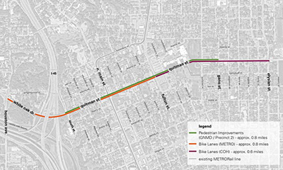
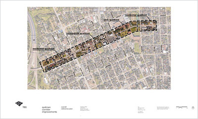
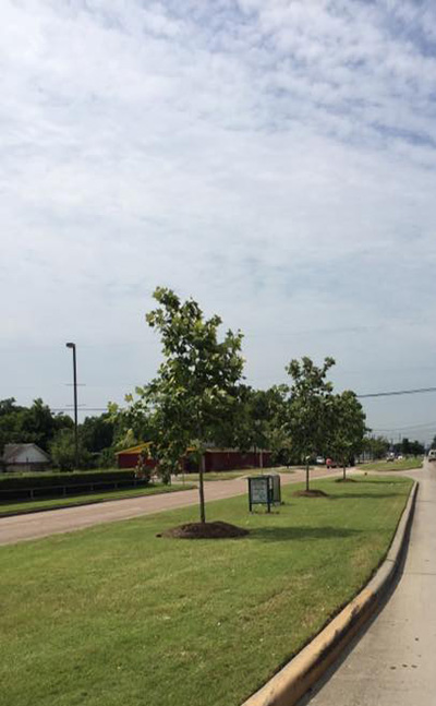
The Quitman Pedestrian-Transit Improvements Project is GNMD’s first capital infrastructure project. It includes improvements to the pedestrian realm, such as ADA accessible sidewalks and ramps, landscaping and streetlights. The streetscape improvements along Quitman Street will enhance the sense of place and preserve the cultural fabric by augmenting the overall quality of the area. The project extends along 0.72 miles of Quitman Street from South Street to Gano Street and is currently under preliminary design.

GNMD received the Houston-Galveston Area Council (H-GAC) 2015 Transportation Improvement Project (TIP) Call for Project Funding for the Quitman Pedestrian Enhancements Project. The Quitman Corridor history that assisted in the the H-GAC TIP Call for Projects includes the following studies:

  • The Northside Livable Center Study identified the Quitman and Fulton Street area as the “heart” of Northside. The study recommended pedestrian and streetscape improvements along main north/south and east/west streets and streets within close proximity of new transit stations.
  • The City of Houston Heights-Northside Sub-Regional Mobility Study recommended that Quitman Street be reclassified as a Major Collector and the multimodal classification identified it as an Urban Street due to the area context and projected volumes of the corridor.
  • The Greater Northside Management District Pedestrian/Transit Access Master Plan scored Quitman Street with a Pedestrian Level of Service (PLOS) letter grade of D from North Main to Hardy Street. The recommendation was given to improve pedestrian infrastructure on corridors that have failing infrastructure by installing pedestrian-oriented lighting, ADA ramps and crosswalks where needed.

Lyons Enhancement Project (Completed 2019)

GNMD Partners: Houston BCycle, Houston Bikeways Program, Saint Arnold Brewing Company

In 2015, Saint Arnold Brewing Company hosted their first 5K with 1,900 attendees. By 2019, the event had grown to 4,000 attendees. The Lyons Avenue Enhancement project was funded from proceeds from the 5Ks. In 2019, a Houston BCycle station was installed at Saint Arnold’s to enable residents to enjoy the Lyons Avenue bike lanes installed by the Houston Bikeways Program.

GNMD Maintenance Partner:

Capital Project Plans performed by other entities

Houston Avenue & White Oak Drive Esplanade (Completed 2019; Ongoing Maintenance by GNMD Starting Summer 2020)
Constructed by Community Partner: Memorial Heights Redevelopment Authority/TIRZ No. 5

In 2019, Memorial Heights Redevelopment Authority/TIRZ No. 5 completed the intersection improvements of Houston Avenue and White Oak Drive to include the realignment of the intersection to improve safer crossing conditions and connectivity to park and bike routes. The project included the beautification of the gateway space at the northeastern corner of the intersection with new roadway pavement, traffic signals, shared use path, bicycle amenities, pedestrian facilities and landscaping. The old clock was refurbished to decorate the new greenspace. As a maintenance partner, GNMD will maintain the Esplanade project landscaping.

GNMD Stakeholders for Capital Project

Plans by other entities:

  • City of Houston Resiliency Plan – Resilient Houston provides a framework for collective action for every Houstonian; our diverse neighborhoods and watersheds; City departments; and local, regional and community partners.
  • Complete Communities – The Near Northside Complete Communities Action Plan outlines the vision, policies, goals and projects identified by stakeholders and that work toward a vision of a healthier, more resilient, prosperous and equitable future for the community.
  • Elysian Viaduct – This project includes the Elysian Viaduct bridge reconstruction from Brooks to Commerce Street to improve safety, accommodate population growth, enhance mobility and improve connectivity in the local area. The Texas Department of Transportation (TxDOT) is finalizing the reconstruction of the Elysian Viaduct bridge from Brooks to Commerce Street. GNMD partnered with former Senator Sylvia Garcia’s office to support the painting of the columns under the new bridge. Artist Nicola Parente finalized the color scheme.
  • Halls Bayou – With new trails, pedestrian bridges, wayfinding, educational signage, benches and landscaping, Halls Bayou Greenway creates spaces for exploration and play, including a playground for children with disabilities; playing fields; trails; and a large, scenic detention basin with wetlands designed for flood control.
  • Hardy Toll Road Downtown Connector – This project extends the Hardy Toll Road from its current southern end at the I-610 North Loop into downtown Houston. When complete, the project will give commuters a direct 25-mile link between downtown and destinations to the north and will allow drivers to bypass congestion at I-610 North, I-45 and I-69.
  • Heights Northside Mobility Study – The area defined by this study is bounded on the east by I-69,  on the south by I-10 and on the north and west by I-610. The study will identify near- and long-range projects that promote better mobility.
  • High Speed Rail – This project involves the development, design, construction, finance and operation of a high-speed passenger train line that will connect North Texas and Greater Houston in less than 90 minutes.
  • Houston BCycle – Houston BCycle is operated by Houston Bike Share, a local 501(c)(3) nonprofit. The organization provides access to bike share that fosters recreation, mobility and personal wellness. Multiple locations have been installed in the Northside and expansion plans exist. 
  • Houston Bike Plan – The Houston Bike Plan was adopted in 2017 to implement projects in the Near Northside. Projects have been included on Lyons Avenue, Hardy Street, Elysian Street, Kelley Street and McKee Street.  Future short-term projects include Burnett Street, Quitman Street, Cavalcade Street and North Main Street.
  • Houston General Plan – Plan Houston describes a vision for Houston’s future and identifies the policies, plans and programs for achieving this vision.
  • Little White Oak Bayou Trail (White Oak Music Hall) – This short trail (0.3 miles) is part of the Houston emerging trails system and is wheelchair accessible. White Oak Music Hall is located at 2915 N. Main (at North Street) and is about 1.5 miles north of downtown.
  • Lyons Avenue Underpass – This project involves the proposals to construct a new underpass at Lyons Avenue below three sets of railroad tracks, including the construction of new bicycle lanes and sidewalks on both sides of the street.
  • METRORail Red Line Schedules & Maps – METRO identified bike and pedestrian project improvements along the Red Line to maximize multi-modal transportation opportunities.
  • METRONext – The METRONext Moving Forward Plan is a plan for traffic that proposes expansions across several types of transportation and investments in service and accessibility.
  • North Houston Highway Improvement Project – City of Houston – Using feedback from community workshops and written comments, the City and its technical team have developed alternative designs to improve and change TxDOT’s North Houston Highway Improvement Project. The workshops addressed issues like housing, flooding and more.
  • North Houston Highway Improvement Project – Texas Dept. of Transportation (TxDot) – This project is a planned reconstruction of I-45 from Beltway 8 to downtown. TxDOT proposes improvements to manage congestion, enhance safety, expand multi-modal opportunities, accommodate future demand and improve operational efficiency. 
  • Walkable Places – As areas in Houston attract higher density commercial, office and multifamily residential developments, there is an opportunity to create more vibrant, walkable streets that support alternative modes of transportation. Lorraine Street and Hogan Street were chosen as part of the first pilot program. 
  • White Oak Bayou – White Oak Bayou will include Watonga Parkway Park (home to one of Houston’s largest bat roosts), T.C. Jester ParkStude Park, White Oak Park, and Hogg Park.  In 2018, a hike-and-bike trail was completed to connect White Oak and Buffalo Bayou at the foot of the University of Houston-Downtown. This connects Houstonians to downtown area, transit centers and recreational spaces.